The 17th and 18th centuries
Roads, canals and railways
The growth of 19th century Stonebridge
Industry and social conditions
The post-war housing estate
Local history articles
Stonebridge is situated in southern Brent, on the Harrow Road between Harlesden and Wembley.
The 17th and 18th centuries
The original ‘Stone Bridge’ took the Harrow Road over the eastern branch of the River Brent in the late seventeenth century. Other bridges over the Brent were wooden at that time.
By 1746 there were four buildings there, including Stonebridge Farm, then at least 200 years old. An inn called the 'Stone Bridge' existed by 1770, renamed the ‘Coach and Horses' by 1790. The painter George Morland often visited the area, and undertook to repaint the pub sign for the proprietor, but his servants mistakenly chopped it up for firewood. The spot was popular with anglers.

Roads, canals and railways
Willesden Parish Vestry, who managed the roads at this time, arranged for a tollgate to be set up on the Harrow Road to raise money for maintenance and repair, in 1801. In 1811 a small feeder canal for the Grand Junction Canal (now the Grand Union), was cut through the district going from Kingsbury to Lower Place. The course of the river was later simplified. By 1905, it no longer divided in two just north of the Harrow Road.
The London and Birmingham Railway came to the district in 1836. This was a considerable engineering achievement, involving removal of 372,000 cubic feet of earth to build an embankment, and construction of a viaduct by railway engineer Robert Stephenson. The Midland and South West Junction Railway followed in 1868.
The growth of 19th century Stonebridge
There were police at Stonebridge since 1839, perhaps to prevent highway robberies, which were a hazard in London’s rural areas. A police station was built in 1851, along with eight houses. By 1855, the Harrow Road was straightened to create the Craven Park triangle. Records show the existence of a shop and beer retailer here. The rural character of Stonebridge began to change at this time. .
Willesden Junction station opened in 1866, making Stonebridge attractive as a commuter suburb. Architect H. E. Kendall designed a select private estate in the 1870s. Originally conceived as ‘Harlesdon Park’ but soon renamed ‘Stonebridge Park’, the estate prospectus boasted ‘new villas for city men’ in Italianate style, and claimed views of the Surrey hills.

The estate never became as grandiose as originally intended, but by 1876, there were 60 villas, along with the Stonebridge Park Hotel on Harrow Road.

The estate was home to many Willesden local government officials, including local historian Frederick Augustus Wood, whose papers are available in Brent archive. The Stonebridge Estate has since seen successive waves of development in the twentieth century. Now only the Stonebridge hotel, 1, and 2 Moreland Gardens (‘Altamira’ and F. A. Wood’s former home, ‘Hurworth’) remain, but as of 2021, there is a proposed new development to replace them.
The housing built after Stonebridge Park was less grandiose and of lower quality. In the 1880s and 1890s, houses were built west of Stonebridge Park in Melville, Brett and Barry roads. These terraces and shops were for tradespeople serving the estate. Hillside, where Harrow Road descended towards the bridge, became a thriving shopping centre until the late 1950s.
The church of St. Michael and All Angels, built in 1891, became the centre of a parish a year later. After 1901, there was little building, and the larger houses were divided into flats or bedsits. Stonebridge was rapidly losing its middle-class character, as industry moved into the area.
By 1920, there were industrial premises, especially factory laundries, along the eastern and southern edges of the area by the railway lines and in Barry Road. Two schools opened before the First World War. The Coach and Horses became known for its skittle alley, gymnasium, and for its proprietor, and trainer of prize fighters, the 39-stone 'Jolly Jumbo' Ecclestone.
Industry and social conditions
In the early twentieth century, Stonebridge became increasingly industrial, and more working-class. Willesden's sewage farm operated there from 1886 -1911. In 1902, McVitie's biscuit factory opened nearby and by 1914, there was a brick works by the railway.
In 1899, an attempt to build houses near the sewage farm failed, but after the First World War, the Brentfield estate was built at the site. The scheme suffered drainage problems, and 200 homes were flooded in 1928. Fewer homes were built than the 1,000 originally planned.
By 1929, the streets built to serve the Stonebridge Park estate had become independent of it with their own character. Barry Road was an upper working-class community consisting of men in regular work.
Brett Road however, was considered a slum. Many of the men had irregular employment, while women worked in the local laundries.
In 1911, the White Heather Laundry sank a borehole for water. To reach clear water they had to drill deep, beneath London clay, where they discovered traces of oil. The company decided to investigate further, but there was not enough oil to make extraction commercially viable (the name Artesian Close, at the laundry site reflects this venture). A further attempt to find oil in 1947, at Gibbons Recreation ground nearby, was unsuccessful. In 2017, a company applied for a fracking licence to drill on the laundry site but locals and the council firmly opposed the application, and the company has since dissolved.
There was some residential redevelopment in the 1930s; a few semi-detached houses from that period still survive on Fawood Avenue (named after F.A. Wood).
From 1933 Willesden's town planners concentrated industry near the St. Raphael's estate. A railway goods depot and a trolleybus garage were important local employers by the end of the Second World War. During that war, a honeycomb of air raid shelters under Stonebridge recreation ground protected several thousand people.
An unusual local feature is the structure known as the Stonebridge Park aqueduct, built in 1933 to take the canal over the North Circular Road. It was partially damaged by an IRA bomb in 1939. The current aqueduct dates from 1993.
The post-war development
In 1949, Stonebridge's population was 17,641. The road system was inadequate, many houses were overcrowded and some were derelict. The council devised a plan to clear the slum housing and redevelop 98 acres of Stonebridge with 2,169 high-rise dwellings.
The shopping centre on Hillside vanished and whole streets were wiped off the map. The first high-rise blocks opened in 1967. By 1978 there were many more, together with a small shopping precinct.
Stonebridge had been heralded as ‘one of the most up-to-date estates in London and an area to be proud of.’ Yet already in 1977, the estate was notorious for broken lifts and even before it was finished, the residents threatened a rent strike. The estate had high levels of deprivation and many residents felt neglected by the council. It then became plagued by a poor reputation as a ‘problem estate’ noted for drugs and gun crime.
The area west of the River Brent, developed slowly, although Stonebridge Park station opened as early as 1912. The most striking buildings are the 1965 21-story Station House, the first tall tower block in Brent (now called Wembley Point), which started out as a workplace for London Weekend Television, and the former Unisys buildings, a Brutalist pair of crescent shaped office blocks from the 1970s, designed by architects Richard Seifert & Partners.
For several years, Stonebridge was the focus of Operation Trident, which began as a community initiative in 1998, and then became a unit within the Metropolitan Police aimed at combatting gun and drug crime amongst London’s black communities. The tower blocks were demolished and the area redeveloped again in the 1990s with small-scale housing developments overseen by the Stonebridge Housing Action Trust, which improved the environment. The bright and colourful Fawood Children’s centre is a noteworthy local social and community facility designed by architect Will Alsop and completed in 2004.
By the 1990s the Unisys buildings West of the River Brent were abandoned. As of 2021, Brent Council are working with the owners to redevelop the area with sports, business, community and leisure facilities as well as new homes for local people. Wembley Point is being converted into flats.
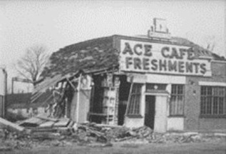
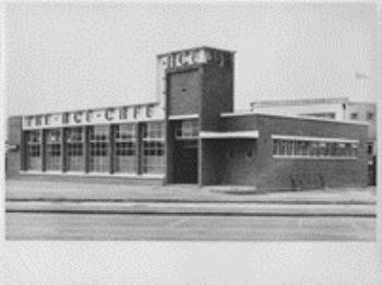
Two other local landmarks are particularly noteworthy. At the North Circular, the Ace café opened in 1938, to serve truck drivers 24 hours a day. It was badly damaged during the war and rebuilt in 1949. It soon attracted motor cyclists and was an important fixture of the rock and roll culture of the 1950s. The café closed in 1969, but re-opened in 1997 and now has satellite branches in locations as far afield as Orlando and Beijing.
 |  |
| Ace Cafe, Bomb Damage, 1940 | The New Ace Cafe, 1948 |
Another striking landmark nearby in neighbouring Neasden is Neasden temple, the BAPS Shri Swaminarayan Mandir, completed in 1995.
Stonebridge is an area of Brent that has physically changed considerably within a relatively short period. Independent filmmaker Patrick Keiller made his first short narrative film Stonebridge Park in 1981, which shows historical footage from Stonebridge as a backdrop to his monologue.
Stonebridge also provided the setting for Julian Henriques’ reggae musical film Babymother (1998), using a cast of local people.
As of the 2011 Census, Stonebridge Ward had the highest number of social rented households.
Local history articles
Find out more about this area by looking at our local history articles, written by volunteer researchers and members of local history societies:
- 1 Morland Gardens: How significant is 'significance'? (.pdf, 819.5kB) Read about the Victorian villa in Stonebridge
Self-guided walks
- Brent Walk: The Heart of Wembley, Brent River Park and BAPS Shri Swaminarayan Mandir Temple (.pdf, 4.00MB)
Archive copies
- Homes Fit for Heroes: Willesden Council’s Brentfield Housing Scheme A facsimile copy of a booklet produced in 1921, with information, plans and pictures about the area's first council housing estate. (The original document is in the local history collection at Brent Museum and Archives, LHC/1/HOU/3.)
Further reading
Brett-James, N.G. - Middlesex (Robert Hale, 1951)
Day, J.R. - The Story of London's Underground (London Transport, 1974)
Elsley, H.W.R. - Wembley Through the Ages (Wembley News, 1953)
Field, J. - Place-Names of Greater London (Batsford, 1980) Hewlett, G. (ed.) - A History of Wembley (Brent Library Service, 1979)
Mills, A.D. - A Dictionary of London Place Names (Oxford University Press, 2001)
Snow, L. - Brent, A Pictorial History (Phillimore, 1990)
Victoria County History: Middlesex Vol. IV
Wadsworth, C. - Traditional Pubs of Brent, Volume 2 Wembley (CAW Books, 1999)
Harrison, E. ‘In Stonebridge Park’ in Hatherley, O. (ed.) The Alternative Guide to London Boroughs (Open House, 2020)
Drilling for Oil and Gas in Willesden? (kilburnwesthampstead.blogspot.com)
Fracking could begin in London after 'multi-million' pound natural gas find | London Evening Standard | Evening Standard
Pathe News: IRA bomb outrage at Stonebridge Park Aqueduct – video footage